How Autonomous Vehicles Can Turn Urban Forms Upside Down… or Maybe Just Sideways!

Figure 1: A street that has been optimized as a result of a reduction in vehicles from AV adoption. Source: https://www.cnu.org/publicsquare/2018/03/12/street-design-implications-autonomous-vehicles

The concept of having cars that can drive themselves on our streets without a human operating them still seems like a long way down the road. That being said, driving automation is among the hottest topics of transportation discussions these days and has gained lots of criticism and applause.  The purpose of autonomous vehicles is to make life easier for everyone. Just picture sipping coffee and making plans for the day while relaxing in your autonomous vehicle (AV); this is the advertised experience, anyway. Gone are the days of having to drive home from work during rush hour or wake up at five in the morning to make it to the bus or subway in time. Despite offering many promising solutions to current issues, such as reducing environmental pollution, eliminating the burden of driving, and saving time (and money if carsharing is considered), many people wonder how our cities and urban forms would change upon their rise.

Just as railways and trams transformed our cities in the 19th century and private cars reshaped them in the mid-20th century, the rise of autonomous vehicles in the 21st century has the potential to redefine our urban landscape and the role of transportation infrastructure in our cities.

Now let’s talk about a few potential ways that AVs can impact and change our cities.

Reshaping urban parking and space usage with self-driving cars

The first and most compelling scenario is what will happen to all the parking spaces that currently exist in our cities. The impact on parking depends on how many AVs are in use and whether people own them individually or share them with others. If AVs are widely shared instead of owned individually, it could free up parking space. Certain parking spaces may be used for other purposes, such as residential complexes, shopping malls, or new construction in general. The available on-street parking spots can be potentially used in specific areas where there is a high volume of daily pedestrian passengers and can be reallocated to spaces for street vendors without impacting the traffic flow. In cases where shared self-driving cars are used a lot and don’t need to park as much, they might return to depots in less expensive areas on the outskirts of the city. This means we might need fewer off-street parking lots in the city center. But we’ll still need space for passengers to get in and out, especially at transportation hubs and major city spots like offices and public buildings. In addition, AVs can also park more efficiently, taking up less space. They can even park in cheaper areas outside the city when they’re not needed, so parking doesn’t have to be near popular places. However, these changes will greatly affect how cities earn money from parking, which is necessary for funding city projects.

Improving the look and feel of our public spaces

Reducing the number of cars parked on our city streets opens up a great opportunity to reimagine and reshape our urban spaces. Instead of endless rows of parked cars, we can repurpose this valuable land in ways that not only make our cities more appealing but also have a positive impact on the environment. This transformation allows us to allocate the newly available space for eco-friendly transportation modes like biking, walking, and efficient public transit systems. These alternatives not only reduce pollution but also contribute to the aesthetic aspects of our cities.

Furthermore, the transition to self-driving cars, especially electric ones, means that we won’t need as many traditional fuel stations in every neighborhood anymore. This change provides a unique chance to convert these locations into something that benefits our communities. Before this can happen, some sites might need environmental cleanup. However, once that’s taken care of, we can think about innovative uses for these spaces in every neighborhood. Perhaps they could become convenient community stores or convenient spots for picking up online orders. In some urban areas, combining commercial spaces with housing or offices could make the most efficient use of these sites. This could lead to more vibrant, mixed-use developments that enhance the neighborhood’s character and provide a live-work-play environment. In any scenario, this raises an essential question of how we can best utilize these prominent and easily accessible locations to enhance the well-being of our communities.

Impact of AVs on property values and planning

The impact of autonomous vehicles on property values and urban planning is noteworthy. While the age-old adage of “location, location, location” remains crucial, self-driving cars introduce some intriguing shifts. These vehicles have the potential to boost property values in certain neighborhoods where easy access to self-driving transportation is a selling point. However, this trend might not hold true everywhere, as neighborhoods heavily reliant on prime locations for commuting could witness stagnant or decreasing property values.

The convenience of self-driving cars in commuting could lead to shifts in residential preferences, possibly drawing people away from crowded urban centers to the suburbs. While suburbanization may gain momentum, this doesn’t necessarily mean city centers will be abandoned. In response to these changes, effective urban planning and land-use policies are vital. The rules governing where buildings can be constructed and how land is utilized must adapt to this evolving transportation landscape. Striking the right balance between building in open areas (green fields) and optimizing existing spaces (infill developments) is crucial for creating more livable and efficient cities that cater to a variety of lifestyle preferences.

Conclusion

Fully self-driving cars may become common in cities within the next 10–20 years. This would have big impacts on city planning and transportation. Studies show different possible results for cities when self-driving cars are widespread. Some think self-driving cars will help city centers by providing less parking space. This would allow more buildings and public spaces downtown. But others believe self-driving cars will increase suburban sprawl. People may live farther out if cars can drive themselves. Cities should plan now for the changes self-driving cars may bring. Parking and roads downtown may need less space. Cities need ideas to reuse this space in good ways, like for housing, parks, or offices. Cities also need to decide if self-driving cars should mostly replace mass transit like trains or complement it. Policies could make self-driving cars link to transit hubs rather than compete. This could reduce traffic and keep cities livable. The future impact of self-driving cars on cities is not just about technology. It depends on how cities manage and regulate these vehicles. With smart policies, cities can steer self-driving cars to improve life and space for people.

References

Here’s How Driverless Vehicles Will Utterly Transform How Our Cities Look. (n.d.). Retrieved from Futurism: https://futurism.com/heres-how-driverless-vehicles-will-utterly-transform-how-our-cities-look

Legêne, M., Auping, W., Homem de Almeida Correia, G., & van Arem, B. (2020). Spatial impact of automated driving in urban areas. JOURNAL OF SIMULATION, 295-303. Retrieved from https://www.tandfonline.com/doi/epdf/10.1080/17477778.2020.1806747?needAccess=true

Rice, A., & Tomer, A. (2017, October 16). How will autonomous vehicles transform the built environment? Retrieved from Brookings: https://www.brookings.edu/articles/how-will-autonomous-vehicles-transform-the-built-environment/

Shaver, K. (2019, July 20). City planners eye self-driving vehicles to correct mistakes of the 20th-century auto. Retrieved from The Washington Post: https://www.washingtonpost.com/transportation/2019/07/20/city-planners-eye-self-driving-vehicles-correct-mistakes-th-century-auto/

Stead, D., & Vaddadi, B. (2019). Impact of AVs on property values and planning: A review of recent scenario studies. Cities, 125-133. Retrieved from https://www.sciencedirect.com/science/article/pii/S0264275118313945 casa_token=2s4FqqImwssAAAAA:vLPJ3dlgFQdCxJfPC-fk9_FB-Ly2oiCbIe68BkqgZtLQ34tdt47_UTWdlsaC57dEuPs-037A
A history of underfunding and inequity. How the United States of America can revitalize its transportation infrastructure.

Creation through displacement

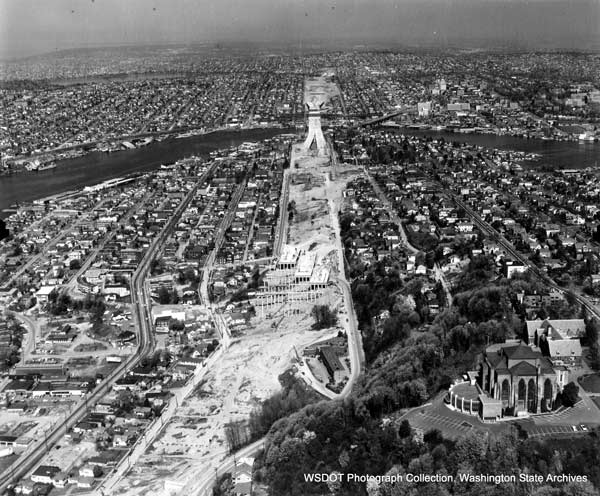
In 1956, the Interstate Highway Act was passed to construct a nationwide system of 40,000 highway miles, costing $24.8 billion (U.S. Department of Transportation , 1996). These highways were intended to connect urban centers and rural communities along their route. As these interstates were developed, there was a push to ensure the highways went into the downtowns of each urban area. This push was detrimental to communities of color surrounding these urban downtowns because the routes of these highways carved through these neighborhoods.

Image of highway construction in Seattle, WA.
Image of highway construction in Seattle, WA (Source: Washington State Department of Transportation)

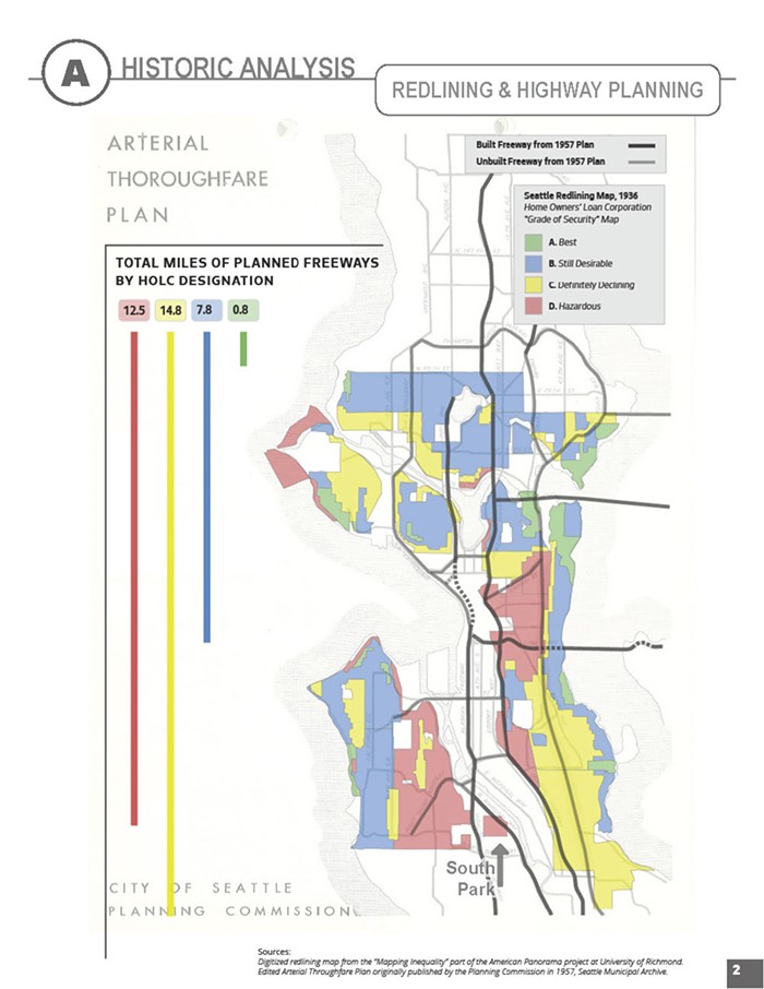
The neighborhoods determined to have highways carved through them were often communities of color and low income  (King, 2021).  Many of these communities were redlined in the early 1900’s.  Redlining was a discriminatory system set up by the federal government.  Communities in urban areas across the country were ranked in the following categories: best, still desirable, definitely declining, and hazardous  (Polk County Housing Trust Fund, 2021).  These rankings were identified based on the racial, ethnic, and income makeup of neighborhoods.  Maps were then created that included discriminatory descriptions of these neighborhoods. After these rankings were created, certain services and investments were withheld from certain areas. 

In many urban areas across the United States of America, the areas identified as definitely declining and hazardous are where the current highway systems are currently located.  This can be seen below with the City of Seattle.  The image also showcases how much highway is located within each redlining ranking.  It provides a clear insight as to how disproportional the impact of highways was on redlined communities.  Upon constructing these highways, neighborhoods could not access areas they could easily walk to before.  This inaccessibility created barriers to accessing jobs, schools, grocery stores, and so much more.  Not only were these services inaccessible anymore, but the social cohesion throughout the neighborhood often dwindled to the side of the highway it was on.

Image of highway construction in relation to redlined areas in Seattle, WA.
Image of highway construction in relation to redlined areas in Seattle, WA (Source: City of Seattle Office of Planning and Community Development)

An era of decline

The transportation infrastructure that impacted redlined communities has been in steady decline across the United States of America over the past several decades. In 2021, the American Society of Civil Engineers (ASCE) scored America’s infrastructure as a C-. This grade is the highest rating for America’s infrastructure since 1998.  Looking a little deeper, ASCE stated that one in three bridges need rehabilitation, and one in five roadways were in poor condition in 2019.  To improve these bridges and roadways to an acceptable condition, there would need to be approximately $554 billion of available funds for these types of projects (American Society of Civil Engineers, 2021).  For years, funding for addressing the declining infrastructure has been crucial to every president’s platform since the Obama Administration.  Although this was a part of their platform, nothing came to fruition until 2021.

A new hope

The Infrastructure Investment and Jobs Act (IIJA) was passed in 2021. This landmark act allocated $1.2 trillion for transportation and infrastructure spending  (President Joeseph Biden, 2021).  According to the White House, this funding will be utilized to “repair and rebuild our roads and bridges with a focus on climate change mitigation, resilience, equity, and safety for all users.”  This includes investing $110 billion into infrastructure rehabilitation, creating new programs related to safety and reconnecting communities, and much more.  

The Reconnecting Communities program was created under the passing of IIJA.  According to its website, the program’s focus is to: 

  • Prioritizing disadvantaged communities; 
  • Aiming to improve access to daily needs such as jobs, education, healthcare, food, and recreation; 
  • Fostering equitable development and restoration; 
  • Reconnecting communities by removing, retrofitting, or mitigating highways or other transportation facilities that create barriers to community connectivity, including mobility, access, or economic development.

These points directly align with rectifying the negative externalities within low-income communities of color due to the 1956 Interstate Highway Act.  A project that has already received funding includes the City of Kalamazoo for its reconnecting communities pilot project for the Kalamazoo and Michigan Ave project.  This project addresses the Michigan DOT designating both roadways as one-way streets for higher speeds and volume 60 years ago (U.S. Department of Transportation, 2023).  Due to this configuration, the surrounding neighborhoods had to cross five roadway lanes to cross the street.  The proposed configuration of the roadway through the reconnecting communities program is to implement complete streets principles to make the roadway incorporate transit and bike infrastructure.

Concept design for Kalamazoo’s Reconnecting Communities Project (Source: Imagine Kalamazoo)

Too good to be true?

The passing of IIJA and implementation of the Reconnecting Communities program provided an influx of funding to address declining infrastructure and rectify the issues the infrastructure has created.  While these projects are critical in rectifying the ramifications of the 1959 Interstate Highway Act, there is concern that these projects may displace these communities.  This displacement of the historic community is called gentrification. Gentrification is when increased investment occurs in a historically disenfranchised community.  The influx of investment into the community for amenities or improved services then encourages wealthier people to move into this area.  This influx of wealthier people increases the cost of living for the entire community.  Making lower incomes (usually the original population) leave. 

An example of a project similar to the Reconnecting Communities program is the City of Boston’s Big Dig project.  This project buried the highway through the City of Boston.  Making a more inviting and walkable green space on top.  This environment made property along this route go from undesirable to desirable.  Making the conditions right for gentrification to occur.

Image of before and after of Boston’s “Big Dig” project (Source: Research Gate)

Communities can address gentrification in a variety of ways.  These methods could include utilizing land trusts to purchase properties and keep them at lower costs, including mixed-income residential developments, and including the community at every step of development within the neighborhood.  

Conclusion

The United States of America has a long history of discrimination and displacement.  This discrimination can be seen within the land use realm through redlining and displacement through the 1959 Interstate Highway Act.  As the United States continues to address these wrong doings, it is crucial to consider the repercussions of each policy, and if they are not considered, the same type of displacement and discrimination can occur. 

References

American Society of Civil Engineers. (2021). 2021 Report Card for America’s Infrastructure. Retrieved from America’s Infrastructure Scores a C-: https://infrastructurereportcard.org

King, N. (2021, April 7). A Brief History of How Racism Shaped Interstate Highways. Retrieved from National Public Radio: https://www.npr.org/2021/04/07/984784455/a-brief-history-of-how-racism-shaped-interstate-highways

Polk County Housing Trust Fund. (2021). Redlining in DSM. Retrieved from The History: https://www.redliningindsm.com/h

President Joeseph Biden. (2021, November 6). The White House. Retrieved from Fact Sheet: The Bipartisan Infrastructure Deal: https://www.whitehouse.gov/briefing-room/statements-releases/2021/11/06/fact-sheet-the-bipartisan-infrastructure-deal/

U.S. Department of Transportation . (1996). Federal-Aid Highway Act of 1956: Creating the Interstate System. Retrieved from Federal Highway Administration: https://highways.dot.gov/public-roads/summer-1996/federal-aid-highway-act-1956-creating-interstate-system

U.S. Department of Transportation. (2023). Reconnecting Communities Pilot Program FY 2022 Award Fact Sheets. Retrieved from https://www.transportation.gov/sites/dot.gov/files/2023-02/RCP%20Fact%20Sheets%202022.pdf

California Finalizes Order of 29 HFC Trainsets

Picture 1: Hydrogren Fuel Cell Train by Stadler – source: Railway Age

In early October, the State of California signed an agreement with Stadler, a development firm producing train technology, to supply four zero-emission hydrogen fuel cell (HFC) four-car FLIRT H2 trainsets to the California State Transportation Agency (CalSTA) and the California Department of Transportation (Caltrans), with the potential for an additional 25 trains (Luczak, Railway Age). The agreement for zero-emission HFC trains for the State of California stems from a previous purchase by San Bernardino County Transportation Authority (SBCTA) for two-car hydrogen-powered trains to service the nine-mile, five-station San Bernardino Transit Center-University of Redlands line (Luczak, Railway Age). According to the article on Railway Age, the four zero-emission HFC trainsets will begin routes in 2027 for transportation between Merced and Sacramento as part of the state’s plan to make all its passenger emissions-free by 2035 (Luczak, Railway Age).

Picture 2: Chart of Total GHG Emissions by Sector – Source: EPA

As transportation technology has steadily improved, there has been a push across the globe for zero-emission transportation methods, specifically regarding rail transit. According to the U.S. Environmental Protection Agency, 28% of total U.S. greenhouse gas emissions in 2021 came from the transportation sector (EPA). More specifically, the burning of fossil fuels for electricity, heat, and transportation is one of the largest sources of greenhouse gas emissions (EPA). This is partly because over 94% of the fuel used for transportation is petroleum based, including gasoline and diesel (EPA).

Reducing these greenhouse gas emissions within the transportation sector has become an important goal for the government. The U.S. government has set a goal to achieve a 50-52% reduction in greenhouse gas emissions by 2030, and a net-zero economy by 2050 (Nejikovsky et. al., Railway Age). Reducing the dependence on fossil fuels and promoting the usage of alternative energy sources, such as electric and hydrogen fuel cells, are key steps towards decreasing greenhouse gas emissions within the transportation sector.

What are HFC Trains?

The use of hydrogen as a potential source of fuel within the railroad industry has become an increasingly popular idea, especially because it has little to no greenhouse gas emissions. Hydrogen Powered Rails, hydrail, uses a hybrid configuration of hydrogen fuel cells, batteries, and electric traction motors, converting the hydrogen into electricity, which feeds the batteries to provide a power source for the electric traction motors (Ballard). The chemical reaction between hydrogen and oxygen to create electrical power produces purified water and heat, resulting in zero carbon emissions and cleaner air (Nejikovsky et. al., Railway Age).

Picture 3: Info Graphic on Hydrogen Fuel Cells on Trains – Source: BBC

Hydrogen-powered trains are already being utilized across several countries in Europe with Stadler US Inc. delivering the first hydrogen-powered trains to San Bernardino County Transportation Authority called the ZEMU (Nejikovsky et. al., Railway Age). Using a combination of hydrogen fuel cells and batteries for power, the ZEMU consists of two cars with a power module in between that holds the hydrogen tanks and fuel cells that generate the electrical power (Nejikovsky et. al., Railway Age). This train can transport passengers at a maximum speed of up to 79 mph with seating and standing space to accommodate over 100 people (Nejikovsky et. al., Railway Age).

“We’re driving innovation that’s not just transforming railways, but the very essence of sustainable transportation in America” – Stadler US CEO, Martin Ritter (Railway Age)

Stadler isn’t the only firm developing train technology using HFC. Alstom has produced the Coradia iLint, having a passenger capacity of 300, top speed of 87 mph, and a range of 497 miles before it needs to refuel (Jefferson et. al., Railway Age). Siemens Mobility is testing their Mireo Plus H train which is set to have a top speed of 99 mph and a range of 621 miles, and Talgo is designing fuel cell technology so that diesel trains can be easily converted to hydrogen power without the need for a whole new train (Jefferson et. al., Railway Age).

Advantages of HFC Trains

There are many advantages in using HFC as an alternative to diesel power. The process of creating electricity through HFC only has two byproducts: heat and water. This means that there is no combustion of fossil fuels and no emissions of particulate matter, carbon monoxide, carbon dioxide, or oxides of nitrogen (Jefferson et. al., Railway Age). This makes HFC a clean form of energy.

Another key advantage of HFC is the lack of expensive infrastructure additions. Unlike electrical energy production where substations and transformers are needed, the electrical power from HFC is generated on board the vehicle, reducing construction and maintenance costs (Jefferson et. al., Railway Age). Because all the necessary infrastructure associated with HFC trains are stored on board, governments can gradually add these types of trains to their fleet without having to change the whole system (Ballard). This is an advantage to communities that might not have the budgeted allocation for more than one or two HFC trains per year.

An additional advantage is that HFC trains can be refueled in less than 20 minutes and can operate for more than 18 hours between refueling (Ballard). According to a Department of Energy fuel properties comparison, one pound of hydrogen contains the same energy as 0.4 gallons of diesel fuel (Nejikovsky et. al., Railway Age). This is because hydrogen is both light and has a high energy content. However, this does lead to a disadvantage for HFC. Hydrogen requires high pressure or cryogenic storage tanks (Nejikovsky et. al., Railway Age). This can become a problem for smaller vehicles where the space required for these storage containers becomes an inhibitor. For larger vehicles and equipment, such as railway vehicles, these tanks or storage containers do not have as much of an impact (Nejikovsky et. al., Railway Age).

What does this mean for California?

Communities near railways are disproportionately impacted by negative externalities associated with rail transit. Diesel powered rail cars carrying cargo and passengers are major polluters of greenhouse gas emissions, growing the share of emissions that increase cancer risk, shorten lives, and worsen smog across California (Los Angeles Times). Some of the state’s most polluted and economically disadvantaged communities, such as Commerce, Colton, and San Bernardino, experience long-standing health risks as railways release diesel emissions nearly all day (Los Angeles Times). While the state is taking proactive steps, such as passing policies that, starting in 2030, prohibit the operation of locomotives that are 23 years old or more, and all newly build models would have to be zero-emission by 2035, California still has the nation’s worst air pollution (Los Angeles Times).

Picture 4: Pollution released from train – Source: Los Angeles Times
“The trains belch diesel fumes so pervasive they fill up the houses if windows or doors are open” – Heidi Swillinger, Resident of San Pablo (Los Angeles Times)

Switching to zero-emission trains could have a major impact on reducing greenhouse gas emissions and lowering health risks for critically sensitive communities in the state. The introduction of HFC trains to California is just one step in addressing this significant problem. However, it is up to the corporations within the rail industry to take these next steps to reduce their greenhouse gas emissions and improve the lives of the communities living near railways. The need for transportation is not going to go away. The U.S. economy is built around transportation usage and will continue to rely on it, especially rail transit, to move passengers and cargo. Transportation technology, like HFC trains, are the future and serve as a positive solution toward reducing the dependency on fossil fuels.

References

Burridge, T. (2019, June 20). All aboard Britain’s first hydrogen train. BBC News. https://www.bbc.co.uk/news/business-48698532

California finalizes order for 29 HFC trainsets. Railway Age. (2023a, October 13). https://www.railwayage.com/passenger/intercity/california-finalizes-order-for-29-hfc-trainsets/

First U.S. hydrogen powered passenger trainset testing at TTC. Railway Age. (2023b, October 11). https://www.railwayage.com/passenger/commuterregional/first-u-s-hydrogen-powered-passenger-trainset-testing-at-ttc/

HFCTA hydrogen fuel cell overview. Railway Age. (2022, April 9). https://www.railwayage.com/mechanical/hfcta-hydrogen-fuel-cell-overview%EF%BF%BC/

Los Angeles Times. (2023, March 20). Editorial: Trains are huge polluters. California regulators should clean them up. Los Angeles Times. https://www.latimes.com/opinion/story/2023-03-20/train-air-pollution-california-regulations

Rail. Hydrogen Fuel Cell Powered Rail – Hydrail | Ballard Power. (n.d.). https://www.ballard.com/markets/rail

Sources of greenhouse gas emissions | US EPA. (n.d.). https://www.epa.gov/ghgemissions/sources-greenhouse-gas-emissions

The long road ahead for Amtrak and central Iowa

Amtrak passenger train at a station.
Photo from https://dailyiowan.com/2022/11/07/opinion-why-iowa-city-needs-amtrak/

As a native of the Quad Cities with family in the Chicago suburbs, I am no stranger to making the two hour trip on Interstate 80 and 88. The traffic is usually minimal, with the exception of the never ending construction, but it always felt like a pain to make the trip. You can only imagine the excitement I had many years ago when there were talks of reviving an Amtrak line going from Chicago to Moline (one of the Quad Cities on the Illinois side). Although no substantive action has been taken, and it is looking like it will be a while until there is any, it is worth looking into the initial plan, the benefits of the proposal, and the reason why we have yet to see this happen. 

The push for Amtrak to return to the Quad Cities, specifically Moline, has been an ongoing battle since 2008 when Iowa and Illinois US Senators asked to bring back passenger rail to the area (Hart, 2023). When the proposal was initially brought up by Senators Chuck Grassley, Tom Harkin, and Dick Durbin the hope was to provide service from Chicago to Moline with extensions into Iowa later on. Currently, Amtrak serves the southeast portion of Iowa via the Southwest Chief and from Omaha to Burlington on the California Zephyr (Crumb, 2022). On the Illinois side there are a few more options, but the closest option from Moline or Rock Island is the Galesburg station. 

There has been a lot of revived enthusiasm around the expansion to Quad Cities and beyond, ever since the Biden Administration and Amtrak CEO put out a plan relating to job growth and greater access to Amtrak lines in 2021. In the plan there was a map that showed the proposed updates and additions Amtrak hopes to make, specifically in conjunction with Biden’s new infrastructure plan (Beeman, 2021). With ridership decreasing over the years, both Amtrak and the Biden administration are hopeful to see the excitement for expansion lead to higher ridership. 

Amtrak’s vision of growth.
Photo from https://media.amtrak.com/2021/03/statement-from-amtrak-ceo-on-president-bidens-american-jobs-plan/

Even though the 2021 plan garnered excitement, that enthusiasm has been around the Quad Cities for quite some time now. One of the biggest reasons is that it would serve as an alternative means of transportation. Train travel is largely seen as a greener alternative to car travel. Iowa is expected to see a two lane expansion of Interstate 80 in each direction and with this in mind people have again pushed for action on an Amtrak line to better serve the state. Crumb (2022) said that in a 2013 study, it was estimated that around 300,000 people would utilize a rail option per year from Chicago to Iowa City. As someone who makes frequent visits to locations on the proposed line, I can only imagine that the impact would be much greater 10 years later.

It is also believed that with a train serving central Iowa, business in the area could have the opportunity to grow even more. Crumb (2022) said the new transit option would bring people to live and work in the area and would therefore help alleviate worker shortages in the greater Des Moines area in the long term. 

The extension of Chicago to Iowa City (and eventually on to Des Moines and then Omaha) is contingent first on the extension to Moline. With multiple attempts, the project finally received the appropriate state and federal funding in order to go through with the project, but have not been able to go through because of one company (Teske, 2023). The Iowa Interstate Railroad owns about 55 miles worth of railway in Illinois that need updating for passenger railway. Teske (2023) reported, “The rail company keeps “moving the goal post” in negotiations with the state, the mayor said, adding, ‘It always comes down to money.’” 

Due to the Iowa Interstate Railroad hold up, local, federal, and state policymakers are turning to their last resort to find a solution. State and local officials, specifically, are trying to get Amtrak to get involved. By federal law, Amtrak is able to appeal the Surface and Transportation Board (Teske, 2023). Although unusual to take this measure, Teske (2023) said that this federal law has been around for 25 years. Amtrak has said that it already has attempted to help but Illinois State Senator Mike Halpin stated this was a last resort- “We don’t like to compel private companies to do things, but when they (Iowa Interstate Railroad) are not coming to the table in good faith, it’s time to take a different approach (Teske, 2023).”

In the time since the plan was initially made to bring passenger rail back to the Quad Cities over ten years ago, downtown Moline has made major updates in preparation. The City of Moline built a new hotel, implemented new walkways, and introduced new business to the area, but still no railway. Moline also made updates to their existing train station to make it ready for passenger travel as a multi-model station (Hart, 2023).

Proposal “Multi-Modal Station” in Downtown Moline.
Photo from https://www.moline.il.us/710/Quad-Cities-Multimodal-Station

Even though Iowa has yet to commit to matching federal funds allotted to it if and when Amtrak comes to serve central Iowa, the implementation of railways as an alternative form of transportation could influence positive transit habits going forward. These kinds of habits could help lower our reliance on personal vehicle travel and open more opportunities for public transit use.

References

Beeman, P. (2021, April 7). Amtrak proposes expansion to Iowa City, but state still has no funding. Iowa Capital Dispatch. https://iowacapitaldispatch.com/2021/04/07/amtrak-proposes-expansion-to-iowa-city-but-state-still-has-no-funding/ 

Crumb, M. (2022, December 8). Notebook: Amtrak expansion seen as another sign that passenger rail will reach D.M. … eventually. Business Record. https://www.businessrecord.com/notebook-amtrak-expansion-seen-as-another-sign-that-passenger-rail-will-reach-d-m-eventually-2/#:~:text=When%20completed%2C%20Amtrak%20would%20use,for%20passenger%20traffic%2C%20Martin%20said 

Hart, C. (2023, February 27). Moline: One company is in the way of passenger rail project – wqad.com. WQAD 8. https://www.wqad.com/article/news/local/moline-officials-one-company-stands-in-the-way-of-passenger-rail-project-iowa-interstate-railroad-amtrak/526-789b9345-8b3c-48bf-a48a-5ce70974387b 

Teske, G. (2023, February 28). Update: Moline-Chicago Passenger Rail Needs Federal Intervention. The Quad-City Times. https://qctimes.com/news/local/update-moline-chicago-passenger-rail-needs-federal-intervention/article_9531d7b3-ddbf-5d17-b464-ef7e3f662e05.html 

Revitalizing RideKC: Navigating Challenges and Forging an Equitable Transit Future

Introduction

Kansas City, a growing metropolitan area spanning two states and seven counties, has their fair share of challenges facing public transportation. Affordability, accessibility, and reliability have been pressing issues that have caused the public transit system (RideKC), to fall behind other metropolitan areas. In this blog post, we will explore the complexities of the current transportation infrastructure in Kansas City, highlighting the pressing issues and the potential policy solutions that lie ahead.

The Current Landscape

Kansas City’s transportation infrastructure grapples with multifaceted funding issues due to differences in jurisdictional rules, making it difficult to solve. However, one of the most persistent problems in Kansas City’s transportation system is accessibility. The downtown district and surrounding neighborhoods face a scarcity of easily accessible transportation options, leaving a staggering 12.8% of low-income households with convenient access to public transit (Mansaray, 2022). This places Kansas City at the bottom of the list among metropolitan transit authorities when it comes to accessibility for low-income households.

Mapping the Urban Landscape of Kansas City, MO: Highlighting Public Housing, Low Poverty Areas in Dark Blue, and Current Transit Routes with Red Dots.

Temporary Solutions

In contrast, cities like Portland, Oregon, boast accessibility levels of 95.3% for low-income households, highlighting a large contrast. Furthermore, less than 3% of workers in Kansas City utilize the bus for their daily commutes, highlighting the issues related to public transit usage. Another issue is the dominance of North-South routes with the only three express routes running in the North-South frame, revealing the lack of East-West transit alternatives (Brey, 2022). Clearly, there is an urgent need for change.

To address the current equity issue facing the Kansas City transit system, the city council has taken an innovative approach. Kansas City became the first major metropolitan transit system to offer fare-free public transportation, temporarily eliminating the $8 million in annual revenue. This program is funded through the federal pandemic relief, with goals to encourage more people to use public transportation, spend money downtown, and support the development district (TRANSIT ZERO FARE). While some argue that this program will lead to improvements, others remain skeptical, of this program leading Kansas City in the right direction.

Significant Reform Needed

Addressing the current funding is the first step in finding issues. With geographic difficulties between different municipalities it is even harder for effective management between the Kansas City Transit Authority and the city council, which is essential to ensure that public funds are utilized efficiently and that transportation systems are reliable and meet the community’s needs. However, to truly overhaul Kansas City’s public transportation system, a major focus must be on equity, with low-income communities at the forefront of policy consideration. ensuring that transportation is accessible, affordable, and tailored to meet the needs of sustaining a family.

History of Policies

Several policy initiatives have been attempted to address the challenges in Kansas City’s public transportation system. Notably, the RideKC Bridj Pilot, launched in 2016, aimed to explore on-demand transportation services in the city. Unfortunately, the initiative fell short, with only 597 rides recorded, well below the projected 200 daily rides (‌RideKC: Bridj). The execution was not as efficient as expected, resulting in a cost of $1,000 per ride, emphasizing the need for a more impactful approach (A For Effort).

The Prospect MAX Bus Rapid Transit (BRT) system, initiated in 2005, drew inspiration from a successful model in St. Louis. This innovative transit system introduced features such as frequent service, traffic signal priority, and fewer stops, all designed to ensure quicker and more efficient service. While it significantly improved transportation options along North-South corridors, East-West routes still face challenges, offering an opportunity for future development (ProspectUS).

In 2018, the U.S. Department of Transportation granted $30 million federal grant to expand Kansas City’s Bus Rapid Transit (BRT) system. This expansion will add 10 miles to the existing three MAX BRT routes to the south and introduce a new BRT route that runs from North-South in the development district. Additionally, this policy involves the addition of 12 new buses, the creation of 27 additional stops, and the establishment of two transit centers. These enhancements not only strengthen Kansas City’s public transit infrastructure but also create economic opportunities and growth potential for lower-income households (U.S. Department of Transportation).

The Future of Public Transportation in Kansas City

At the federal level, the bipartisan Infrastructure Investment and Jobs Act, passed in 2022, marks a pivotal era for public transportation in Kansas City. This legislation allocates substantial federal funding to support the development and improvement of public transit systems across the country, including Kansas City (‌President Biden’s Bipartisan).

The funding allocated through this legislation presents a significant opportunity for Kansas City to address long-standing equity issues and enhance its transportation infrastructure. By working together, local governments can strategically allocate federal resources to bridge accessibility gaps that have disproportionately affected low-income households. These funds can lead to expanding transit options, reducing transit-isolated areas, and making public transportation affordable for all Kansas City residents.

The addition of federal support offers a first step for the KCATA to provide efficient, reliable, and equitable transit services. The allocated funding can be used to enhance service reliability and invest in electric buses, contributing to the city’s broader goals of reducing emissions and combating climate change. This commitment from the federal government allows Kansas City to transform its urban layout, stimulate economic development, reduce traffic congestion, and decrease the overall poverty rate within the inner city.

Conclusion

Kansas City’s public transportation system faces several challenges, but it is not without hope. The recent passage of the Infrastructure Investment and Jobs Act at the federal level represents a significant opportunity to address equity issues and enhance the city’s transportation infrastructure. With strategic planning and the effective allocation of federal funds, Kansas City has the potential to become a leader in equitable and sustainable public transit in the United States. It is a journey that promises to not only transform transportation within the city but also improve the lives of residents.

References

  1. Brey, Jared, What Can Cities Learn from Kansas City’s Fare-Free Transit Program? (2022, November 29). Governing. https://www.governing.com/community/what-can-cities-learn-from-kansas-citys-fare-free-transit-program.
  2.  Kansas City’s Zero Fare Transit Program Shows Major Success – And What Still Needs to Be Done. (n.d.). Nextcity.org. https://nextcity.org/urbanist-news/kansas-city-zero-fare-free-transit-program-shows-major-success.
  3. Mansaray, M., August 12, M. I., & 2022. (2022, August 12). Zero bus fare does not equal easy commutes for Kansas City riders • Missouri Independent. Missouri Independent. https://missouriindependent.com/2022/08/12/zero-bus-fare-does-not-equal-easy-commutes-for-kansas-city-riders/
  4. Part 2: Community Needs Index – United Way of Greater Kansas City. (2023, August 23). Unitedwaygkc.org. https://unitedwaygkc.org/2023/08/23/part-2-community-needs-index/.
  5. President Biden’s Bipartisan Infrastructure Law is Delivering in Kansas. (n.d.). Retrieved October 15, 2023, from https://www.whitehouse.gov/wp-content/uploads/2023/02/Kansas-Fact-Sheet-E3.pdf
  6. ProspectUS | Transit Initiatives | KCATA. (n.d.). http://Www.kcata.org. Retrieved October 15, 2023, from https://www.kcata.org/transit-initiatives/max_and_bus_rapid_transit).  
  7. RideKC: Bridj Pilot | Transit Initiatives | KCATA. (n.d.). http://Www.kcata.org. Retrieved October 15, 2023, from https://www.kcata.org/transit-initiatives/bridj.
  8. TransitCenter. (2017, February 24). A For Effort, But So Far, A Bridj to Nowhere. Transitcenter.org. https://transitcenter.org/a-for-effort-but-so-far-a-bridj-to-nowhere/)
  9. TRANSIT ZERO FARE IMPACT ANALYSIS [Review of TRANSIT ZERO FARE IMPACT ANALYSIS]. Mid American Region Council; MARC. Retrieved October 14, 2023, from https://www.marc.org/sites/default/files/2022-04/Transit-Zero-Fare-Impact-Analysis.pdf.
  10. U.S. Department of Transportation Announces $30 Million Grant For Bus Rapid Transit Project in Kansas City, Missouri | FTA. (2019). Dot.gov. https://www.transit.dot.gov/about/news/us-department-transportation-announces-30-million-grant-bus-rapid-transit-project-kansas

Living in the United States without Car

Why do young people dream of studying in America on the other side of the world? IDP Education (2022) lists the answer to this question as follows:

  • Quality of education: Many American schools are included in the top world university lists due to their high education quality.
  • Flexible education: American universities offer numerous courses and programs, allowing students to make their own choices.
  • Opportunities for international students: There are staff dedicated solely to international students. These people organize orientation programs, workshops, and training to help international students adapt to the new social and cultural environment.
  • Diversity: America encompasses various cultures and races within its borders. This helps acceptance by different communities, meeting different people, and being open to global perspectives.

As a result of the factors listed above, many university students aspire to receive their education in the US. However, there is a flip side to this situation. If you have never had any experience with America or haven’t watched a film or documentary about life in the United States, it can be said that you have no knowledge of transportation-related challenges. If you live in the US and don’t have a car, your standard of living may decrease because everything in the US is not easily accessible due to the considerable distances. One of the major reasons for this is urban sprawl.

Definition of Urban Sprawl

Cities provide a platform for us to collaborate in working, innovating, enjoying leisure, and expressing ourselves within shared urban areas.4 However, concentrating the population, economic activities and social environment in a wide area leads to land use waste and environmental damage. This situation is called urban sprawl.  Urban sprawl refers to uncontrolled expansion in both urban and suburban regions, covering extensive areas and resulting in a low-density landscape characterized by significant separation between residential and commercial zones, which has detrimental effects on the well-being of residents in these areas.1 It is also known as suburban sprawl, metropolitan sprawl, and suburbanization, and it is a very common type of development in the United States.

Figure 1. Example of Urban Sprawl

Source: https://www.planetizen.com/news/2022/05/117070-how-urban-sprawl-came-dominate-us-cities-and-how-change

Accessibility studies in the literature often include disabled participants or older adults.3 However, the concept of accessibility should be broader. In my opinion, accessibility should be simply defined as the ability of all living individuals (such as disabled, elderly, children, workers, students, etc.) to freely access and use all physical structures offered as a service to society without needing anyone else.

I am an international student who completed my undergraduate education in Turkey and came to the United States to pursue a master’s degree. I argue that Turkey is better than America in terms of access to basic needs. It can also be stated that some other European countries are better than America in this regard.

If you do not have a personal car and want to go to physical structures like groceries, malls, or schools, the most affordable transportation is public transit. It cannot be said that every American city is the same in terms of public transportation, but the following are some problems related to American transit:

  • Your waiting time can be half an hour or more.
  • There may be limited or no public transit on weekends.
  • You may not be satisfied with the hygiene of the public transportation you use.
  • The fare might be expensive.
  • The travel time on your chosen route can be much longer compared to using a car.
  • There may be no public transit option to reach your desired destination.

Unfortunately, the last point is true, and I experienced it. The places where I have the most difficulty with transportation are supermarkets. Normally, the area where I live is within a 20-minute walking distance from the market, so it can be considered that it is close. However, it is not suitable to walk there due to weather or the weight of the bags on the way back from the market. Additionally, the supermarket parking lots are quite large, so no one walks there either (Figure 1). Another option can be to use transit but public transportation that goes there doesn’t pass through my neighborhood. The other transportation-related problem that I realized is sidewalks. There are sidewalks on most of the roads but if you are not in the downtown area, you would not see anyone on those sidewalks. If you want to eat somewhere, you can get your food without getting out of your car and eat it in your car (Figure 3).

Figure 2. Walmart Parking

Source: https://www.aisleofshame.com/can-you-sleep-in-a-walmart-parking-lot-overnight/

Figure 3. McDonald’s Derive Thru System

Source: https://retailwire.com/discussion/voice-assistant-takes-orders-from-mcdonalds-drive-thru-customers/

Overall, the US has developed almost everything car-oriented, and if you do not have a car, you will have to think twice about leaving the house. It is an indisputable fact that car-oriented development, which is a product of urban sprawl, is not sustainable anymore. That’s why cities should be designed with a human and society oriented because accessibility is the most natural right of every individual who shares the city.

References

1. Editor. (2021, March 16). Urban sprawl: a growing problem – Ledger. Online at https://campuspress.yale.edu/ledger/urban-sprawl-a-growing-problem/

2. IDP Education. (2022). Why study in the USA? 5 reasons. IDP Education Middle East. https://www.idp.com/middleeast/study-in-usa/why-the-usa/?lang=en#:~:text=The%20United%20States%20of%20America,to%20study%20in%20the%20US.

3. Mack, K., McDonnell, E., Jain, D., Lu Wang, L., E. Froehlich, J., & Findlater, L. (2021, May). What do we mean by “accessibility research”? A literature survey of accessibility papers in CHI and ASSETS from 1994 to 2019. In Proceedings of the 2021 CHI Conference on Human Factors in Computing Systems (pp. 1-18). Retrieved from https://dl.acm.org/doi/10.1145/3411764.3445412

4. Rubiera-Morollón, F., & Garrido-Yserte, R. (2020). Recent literature about urban sprawl: A renewed relevance of the phenomenon from the perspective of environmental sustainability. Sustainability12(16), 6551. Retrieved from https://www.mdpi.com/2071-1050/12/16/6551

Traffic management strategies that promote other modes of transport: The Case of Europe and the United States of America.

Introduction

Transportation as a function of economic development makes it an essential infrastructure for the development of every geographical area. Theoretically, researchers, policymakers, and transportation experts define the transportation infrastructure as the heart of the economic development of every city. Therefore, any negative impact on its efficient and effective function affects all sectors of the economy. This makes its management and governance significant to the central and local governments. During the 1990s, the suburban trend, particularly in cities in the United States, made automobiles the only form of transportation for many citizens. This form of urban architecture and rapid urbanization experienced by towns and cities has contributed to traffic congestion (UN-Habitat, 2020; Kuddus et al. 2020). This has tremendously affected the quality of urban life and places a major challenge to transportation experts and city authorities. According to Jayapal & Roy (2016), traffic congestion is a condition that occurs on road networks, which involves the increased queuing of vehicles, increased travel time, and fuel consumption. This usually occurs whenever demand exceeds the capacity of the transportation system. This primarily happens along roads that connect to the central Business Districts or downtown and industries.

Its causes are categorized into two; known occasional and recurring congestion. Occasional traffic congestion occurs during incidents such as road construction, vehicle accidents, severe weather, and special events among others while recurring congestion happens during rush hours, poor signal timing, and sometimes issues regarding parking (Mohandas et al. 20009). This poses numerous threats and problems to the economic development of cities and their residents.

In 2022, the average annual cost of traffic for Americans was 51 hours ($869) and $81 million for the entire country, while in England, the individual cost was about $926 (INRIX, 2020). This could have been minimized if city authorities adopted equity transportation-oriented development which provides affordable housing and efficient alternative modes of transport. However, the use of both the command-and-control and the incentive-based policy instruments has helped in addressing the issue of congestion. These strategies have encouraged other modes of transport such as transit, biking, and walking in many countries within Europe and some cities in the US.

Traffic Management Strategies that Promote Alternative Modes of Transport

This section discusses the key active strategies adopted by countries around the world in the management of vehicular traffic. These strategies have received more attention in countries within Europe than in any part of the world and continue to make a significant impact on urban development.

a. Tolling

Among countries such as Greece, Denmark, and some cities in the U.S., tolling is the primary method used to manage traffic congestion within some specific areas. In some cities, the toll is a flat fee for passenger vehicles and light commercial vehicles despite the distance traveled on the facility. However, the rates are mostly lower for motorcycles and higher for larger vehicles. The objective of the flat toll is to discourage short-distance trips that contribute to congestion.

b. Managed lanes strategies

City authorities adopt this strategy to provide an incentive to the use of other modes of transport such as bus transit, carpool, and vanpool, among others. With this strategy, Heavy Occupancy Vehicles (HOVs) are given higher priority on the freeway by providing a special lane for such vehicles. This works effectively and efficiently with other active traffic management approaches such as tolling, congestion pricing, and other economic-based strategies.

This was adopted in Greece during the 2004 Olympic Games in Athens to facilitate transport to and from the various avenues in the Olympic cities. This strategy is adopted by most cities around the world, especially on tolling highways. In the U.S., HOV lanes are provided in high-traffic zones to disincentivize road users to avoid solo driving which contributes tremendously to traffic congestion.

c. Speed Limits and Speed Harmonization

This strategy has received much attention in cities within the U.S. and Europe. This is enforced to manage traffic flow along streets. However, speed control within neighborhoods and city centers helps in making other modes safe and comfortable. In most cities, vehicles are authorized to drive at speeds of 25-30 mph to facilitate self- and comfortable modes of transportation such as biking, walking, and others.

This creates a safe transportation infrastructure for all city residents. It creates an enabling atmosphere if other services such as grocery stores, coffee shops, and restaurants, among others, are located within walking or biking distance for city residents. This minimizes automobile miles traveled, which contributes to greenhouse gas emissions. Countries such as the Netherlands, Denmark, and Germany have adopted equitable Transportation-oriented development and high-density developments that can sustain the daily running of these services.

d. Building Dense Cities

In recent years, urban and regional planners around the world have been advocating for dense city development through equity Transportation Oriented Development. This system of development which encourages mixed uses is seen as an effective mechanism to combat traffic congestion in big cities. Urban sprawl as a major development challenge in cities within the U.S. has been the major factor in traffic congestion. The suburban development entices residents of big cities to have personal vehicles to enable them to commute to work and return to their homes. This has promoted solo driving in many cities around the world. Therefore, the use of dense development can provide the density needed to promote bus transit and many services within walking and biking distance for residents.

e. Congestion Pricing.

This is an economic incentive-based approach to managing traffic congestion. A pilot study was carried out in 2003 to ascertain its feasibility in England. In 2004, it was successfully implemented in England to manage congestion in its downtown. According to empirical studies, the use of congestion pricing in London (the highest-traffic city in the world) has tremendously reduced traffic congestion (US Department of Transport, 2007; US Department of Transport, 2008; Singh, 2019).

This success has proved that pricing has the potential to reduce roadway congestion. The zone in which travelers are charged is Central London, a region that was the most congested with average speeds of 14.5km/h (9 min/h) despite 85 percent of transport usage. Since its inception in 2004, the strategy has had a positive result.

According to the US Department of Transport (2007), congestion is down by 30 percent with a decrease in all traffic entering the zone of 18 percent (33 percent for automobiles). Though the number of trips into the central part of London has not changed, travelers have switched to other modes, diverted around the zone, or made other changes to their travel behavior. This indicates how pricing can promote high-occupancy vehicle (HOV) lanes, public transit, carpooling, vanpooling, and other modes of transport.

Conclusion

Countries within Europe have done significant works in using traffic management strategies to promote other modes of transport. The control-and-demand and incentive-based approaches have been used in countries such as Germany, Netherlands, England, Singapore, Stockholm, Demarks, and others in managing traffic congestion. These active management strategies especially congestion pricing provide more incentive to road users to use other modes of transport specifically when entering highly detected traffic zones. Countries such as England, Singapore, and Stockholm indicate the effectiveness of pricing in managing traffic. However, its implementation requires city authorities to make an advanced investment in the transportation sector to provide other sustainable modes such as bus transit before its enforcement. Also, the adoption of equity transportation-oriented development can have a substantial effect on the delivery of affordable housing and efficient modes of transport which will reduce traffic congestion.

References

Cervero, R. (2013). Linking urban transport and land use in developing countries. Journal of Transport and Land Use, 6. doi:10.1201/9781003193838-43

INRIX. (2022). Global Traffic Scorecard. INRIX.

Kumar , M., Kumar , K., & Das, P. (2021). Study on road traffic congestion: A review. ResearchGate. doi:10.1201/9781003193838-43

Kuddus , M. A., Tynan, E., & McBryde, E. (2020). Urbanization: A Problem for the rich and the poor? Public Health Review. doi:https://doi.org/10.1186/s40985-019-0116-0

Sohail, M., Maunder, D., & Cavill, S. (2006). Effective Regulation for sustainable public transport in developing countries. Transport Policy. doi:https://doi.org/10.1016/j.tranpol.2005.11.004

UN-Habitat. (2020). World Cities Report 2020: The Value of Sustainable Urbanization. United Nations Human Settlement Programme. Retrieved from 978-92-1-132872-1

Wang, M., & Debbage, N. (2021). Urban Morphology and Traffic Congestion: Longitudinal Evidence from US Cities. Computer, Environment and Urban Systems. Doi: https://doi.org/10.1016/j.compenvurbsys.2021.101676

Mitigating The Effects of Natural Disasters

As history has shown, natural disasters serve as harsh reminders of nature’s strength and the devastation they can inflict on communities. In recent times, the aftermath of such disasters has become increasingly frequent and devastating. With this growing uncertainty, transportation infrastructure and land-use planning play a vital role in a community’s ability to respond to and recover from a disaster. In this post, we will explore the connections between successful disaster response and thoughtful infrastructure and policy along with the importance of educating the community about disaster response and plans.

  1. https://news.ucr.edu/articles/2023/02/07/california-will-inevitably-shake-turkey
  2. https://www.cnn.com/2022/07/30/weather/mckinney-wildfire-northern-california/index.html

Role of Transportation Infrastructure

Transportation infrastructure serves as a lifeline during times of crisis. Accessible roads, bridges, and tunnels are essential for the efficient evacuation of residents from disaster-prone areas. Additionally, transportation systems enable the prompt delivery of emergency supplies, medical aid, and essential resources to affected regions. By investing in resilient and well-maintained transportation systems, communities can greatly improve their disaster readiness, ensuring the safety and well-being of their residents.

The speed at which a community responds to a disaster is crucial. The quicker first responders can safely enter an area, the more lives can be saved. Inaccessible transportation systems can create substantial delays in response efforts. Flooded roadways, fallen trees blocking the road, or fires obstructing the route are just a few examples of how disasters can lead to stopped traffic. Furthermore, transportation systems need to be adaptable because a community’s normal travel behavior can change rapidly in the event of an emergency.

To minimize transit delays, it is necessary to build resilient infrastructure capable of withstanding even the harshest events. One design choice to mitigate infrastructure destruction is the addition of elevated roadways, which can be seen in multiple coastal U.S. cities to ensure proper transportation during floods. Another mitigation strategy could be creating defensible spaces, buffers between vegetation and the roadway, which prevent trees from obstructing roads during forest fires. Lastly, designing roadways with materials suitable for specific conditions is essential when developing in high-risk areas, such as earthquake zones.

THE PROJECT

Mitigation with Policy and Planning

Land use planning also plays a pivotal role in disaster resilience. Proper zoning and land allocation can minimize the devastation of vulnerable areas to potential hazards. For instance, making sure that floodplains and coastal zones are used for recreational purposes rather than residential or commercial developments can mitigate the impact of flooding. By incorporating risk assessment and hazard mapping into land use planning, communities can make informed decisions, prioritizing safety and reducing the potential for future losses.

Recommendations for new codes have emerged as communities face more significant effects from disasters. FEMA, for example, has recommended the adoption of the “NEHRP Recommended Seismic Provisions for New Buildings and Other Structures.” These provisions focus on avoiding injuries and preventing the loss of essential facilities. Adopting these codes can help create more resilient infrastructure to respond to increasingly devastating events.

Alongside the creation of new policies, purposeful land-use planning plays a significant role in disaster mitigation. Being prepared before a disaster strikes is crucial for a community. Avoiding extensive development in hazardous areas is an effective mitigation strategy for protecting lives. An example of this type of land-use planning can be seen in the San Francisco Bay Area growth plan. A team conducted a vulnerability assessment to identify areas prone to earthquakes and flooding with the potential for significant devastation. They then formulated a plan for San Francisco’s growth that prioritized safety and minimized threats as much as possible.

Educating the Community

Although transportation infrastructure and transportation planning are essential for disaster response, the best way to prepare a community for a disaster is through proper education and response planning. An educated community, aware of the community’s emergency response plan, is much more likely to respond to and recover from various events successfully. A comprehensive and easy-to-understand plan set in place enhances community collaboration and significantly reduces potential dangers. By creating a culture of emergency preparedness through education and planning, communities can improve their ability to adapt during a disaster.

Conclusion

The intersection of transportation infrastructure and land use planning is crucial for disaster response and resilience. By designing purposeful infrastructure and effective land-use planning, we can create communities that are better prepared to withstand disasters and recover more efficiently. Through innovative engineering and planning, our country can feel safer and more hopeful for the future. Above all, we must continue building communities equipped not only with proper infrastructure but also with proper emergency education and comprehensive plans.

References

Building Seismic Safety Council of the National Institute of Building Sciences.“Recommended Seismic Provisions for New Buildings and Other

Structures(FEMA P-2082-1).” FEMA, 2019, http://www.fema.gov/sites/default/files/2020-10/fema_2020-nehrp-provisions_part-

3.pdf. Accessed 26 Sept. 2023. 

California Department of Forestry and Fire Protection. “Defensible Space.” Cal FIRE,

http://www.fire.ca.gov/dspace#:~:text=Defensible%20space%20is%20the%20buffer,of%20firefighters%20defending%20your%20home.

Accessed 25 Sept. 2023. 

“Creating Safe Growth Strategies for the San Francisco Bay Area.” United States Enviornmental Protection Agency,

http://www.epa.gov/smartgrowth/creating-safe-growth-strategies-san-francisco-bay-area. Accessed 26 Sept. 2023. 

“I-395/SR 836/I-95 DESIGN-BUILD PROJECT.” Connecting Miami, Aug. 2021, i395-miami.com/the-project/. Accessed 26 Sept. 2023.